Makeup Paddling Around Long Island
For the last three years, I've been part of a group from Sebago Canoe club which is undertaking a multi-year circumnavigation of Long Island. Last year, I had to quit a day early due to my shoulder hurting from recent surgery; I made up 1/2 of that trip last September with our excellent ground crew leader John W. This year, on July 25, John and I made up the rest of that trip with another bike-kayak biathalon, this time between Wading River and Mt. Sinai:
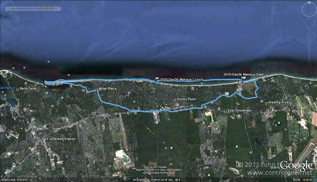
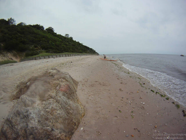
We started in the shadow of the defunct Shoreham Nuclear plant, which was first brought online in the late 80's (when I was living on the East End of Long Island), but shut down shortly thereafter:


It got a bit rainy, but we planned the currents well and made good time...
And, hungry after the 10 mile paddle and hilly 12 or so mile bike ride, we stumbled into an amazingly good homemade dinner at "The Pizza Pie" in Wading River.
I joined the around LI group on its second year, so I also have several days of paddling from the first year to make up. I was hoping to do some of it last year, but my shoulder surgery got in the way. But yesterday, I started whittling away at it, this time solo, since none of my paddling partners were available. I put in at Captree State Park (where I've paddled before), and headed east, along the north side of Fire Island:

There are strong currents by Captree due to the nearby Fire Island inlet, and so I studied the tides pretty carefully and timed it to get about a 3 mph push east. The conditions were great, but the power boat traffic in that area is pretty intense, and I was immediately confronted with a parade of fishing party boats coming out of Captree. Fortunately, much of the Great South Bay is very shallow, so the boats tend to stick to the channels, so I stayed to the north on the way out. My path is a bit jagged due to the channel crossings, which were sort of like running across a busy highway (see video below).

I was getting tired, but with 4 miles left showing on the GPS, I pushed to my chosen target, about 1/2 way down Fire Island: Barrett Beach. This is a beautiful spot, accessible only by boat or by a long walk from one of the surrounding communities. On the bay side are picnic tables:

A quick walk across the dunes (this is apparently the thinnest part of Fire Island) brings you to the ocean:

I jumped in the ocean, and had lunch while drying off. I headed back towards Captree, and along the way stopped by the Sunken Forrest, which apparently had its dock destroyed at some point. It was high tide, and there wasn't really any place to leave my boat, so I pushed on. I passed by Ocean Beach, where my father spent his summers, and stopped to check out the Appalachian Mountain Club's cabin in Atlantique. I've been an AMC member for probably 20 years, but had never made it out to this really nice facility.
I pushed on into the sun, and had a bit of a nerve-wracking crossing back to Captree, with so many power boats and big fishing boats whizzing through the channel, and the chop increasing with the current. But I made it back safe, and in the end, it was about a 24 mile trip. Here's a little video of clips that I shot along the way:
(Note: Somehow this video got an unintended anamorphic stretch--no time to fix it at the moment).
I hope to make up the remaining distance across the eastern part of Fire Island soon...
Update
on 2011-08-24 12:44 by controlgeek
Next segment of the paddle here.