After Years of Chasing, My First Tornado (Rozel, Kansas EF-4)

I've been interested in severe weather as long as I can remember. I chased hurricanes in the 80's, and I've been chasing storms in the plains when I could since 2009. While on sabbatical last spring, I chased severe storms for several weeks in the plains (photo highlights and writeup here), but never caught one of the very few tornadoes that happened last year. So when a major outbreak was forecast on a rare weekend when I was not working, I hopped on a plane to chase in the plains.
I started Saturday (5/18) in Manhattan, Kansas, and headed west and south to get into the zone forecast for significant tornadoes. I filled up on gas and ran a couple errands in Hays, and then headed south. I sat in the tiny town of Rush for a while waiting to see what would happen, and since the models were forecasting storm development a bit later in the afternoon, I decided to head over east to Great Bend to grab some lunch. Of course, as soon as I sat down for lunch, storms started to fire out to my west, heading right back up towards Hays. I was now a bit out of range for these storms, but watching the storms developing just as the short range models predicted, I figured that more storms were to come further south. I started south, and saw the anvil of a developing storm blowing out towards me:

Of course, by this time, the Hays storm had a tornado warning and a report of a funnel cloud, and I was starting to question my decision to head south instead of north. But I stopped for a while near Rozel, and the winds were just incredible. We don't see this kind of wind in the east very much--it was just sustained 20+ MPH, and it was out of the south and just pumping moist air--one of the key ingredients of severe thunderstorms--into the area. Here's the winds knocking around my heavy Nikon D600:
I watched the sky for a while from here, and then decided to roll south. I stopped to watch a huge wind kicking up dust and being drawn up into the storm system:

Rolling into Kinsley, I saw Josh Wurman and the Doppler on Wheels (DOW) armada--these are the mobile radars that try to get close to tornadoes to learn about how they form. So I figured if this storm busted, I wouldn't be the only one to be stuck with a bad decision. I rolled west of town and spotted this, just before 6pm local time:

That's a big fat lowering in the updraft of the main storm system--a good point to watch for development. Rain started falling out of this system (in the distance beyond the lowering):

(The white dot in a circle is me; note too that that purple box on the top left of the screen is a tornado-warned storm aiming right north of Rush, where I sat for at least an hour). This lowering lasted for a while, so I tried some different shots waiting for something to happen.

Eventually, it looked like a wall cloud was trying to get started on the lowering:

At this point, I figured I should start heading north. I got a few miles out of town, and the National Weather Service in Dodge City issued a severe warning on the storm. You can also see now how many other chasers are now on this storm--each of those green dots is a storm chaser.

But while that might look like a traffic jam on spotter network, this is what it looks like on the ground--there's plenty of room out there.

I tried to head north, but this nice paved road turned to dirt. And then mud. With the storm approaching, I didn't want to get stuck in the mud, so I tried to head east, and ended up blasting--at high speed--into a muddy field. With the storm approaching, I figured it was prudent to backtrack south and around to the east and a paved road. Heading back north again on the pavement, I stopped when I saw a funnel starting to drop, almost right in the spot where I had bailed on the dirt road, now several miles to my west:

It reached a bit lower:

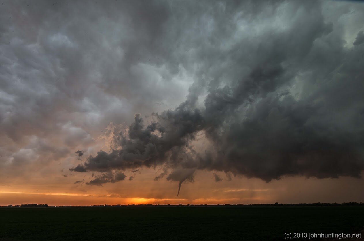
I moved north again, and about 7:25, after I had now been watching this one storm for about an hour and half--touchdown!

After years of trying, it was my first ever tornado!

The storm intensified and moved north east, as I moved north to keep up with it and get closer. I was listening to a local radio station too, and with all the spotter reports and at least one of the many chasers streaming video of the storm, the radio announcer was literally calling a play by play on what I was seeing, which is a great help to the local community.

It was now close to Rozel, where I had shot video of the crazy winds earlier:


The storm now lifted, about 10 minutes after it first touched down:


I thought it was done, but I moved north east some more, and it dropped again around 7:55:


It was now moving away from me north and slightly west, and I moved again:


Eventually only the funnel was left:


And then it was gone, more than two hours since I started on this storm. It was an amazing display of nature's power and beauty, especially since we found out the next day that no one was hurt by this EF-4 storm (rated later by the National Weather Service, in part with data from the DOW trucks I had seen earlier, their write up here). Tragically, one house was severely damaged, but it could have been a lot worse if it had shifted into Rozel or another town nearby.
You can view all my photos on a Google map here, and I also shot some video along the way:


Tired, but excited after finally seeing a tornado, I headed to Wichita for the night.
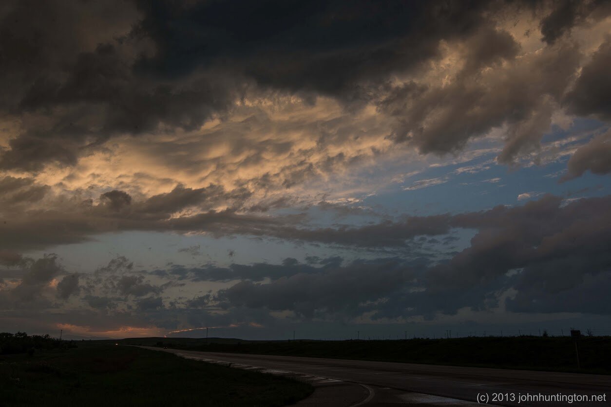
The next day (May 19) I headed south out of Wichita, and was stuck in an internet data hole as a wedge tornado ran into Wichita. Fortunately, this storm wasn't as bad as it could have been; this sky was downstream of those storms:

After a long day of missing storms and driving around with no internet, I ended up in Arkansas City, Kansas, and watched a tornado warned storm system come across the town. It was my first time hearing tornado sirens.
I was about to throw in the towel, but saw an incredible hook on the radar on the tail end of the storm south near Newkirk, Oklahoma, so I headed down there and watched a storm try to make a tornado, but eventually it just fizzled out.


I had to get back to Kansas City for a very early flight the next morning, so I blasted through the line and ran up along the back side of the system:


The lightning was incredible, but I was rushing back to the hotel to try and get a few hours of sleep so I couldn't wait around for it. And then, of course, after 11pm, as I was rolling into the hotel near the KCI airport, Delta emailed me, cancelling my flight and rescheduling me a full day later. So on Monday, I could have been chasing, but didn't have enough time to get south to Oklahoma and back. So--fortunately--I missed the Moore disaster altogether. I did chase a storm system locally in northern Missouri, but I was on the wrong side of the storm when it produced a brief tornado. I did get a lot of experience driving through severe storm rain, though, and saw some crazy flash flooding,


It was an exhausting but amazing weekend, and in many ways I feel like I finished some unfinished business, finally seeing a tornado, and a photogenic one at that. But as I write this, another outbreak is forecast for the plains, and if I didn't have all these end of semester meetings at school, I'd be on my way out there again....
